
Monday, December 11, 2006
New Template

Repast Model of the Week: Fads Model
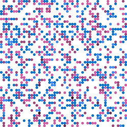 The Fads Model from Tom Carter is a well commented model utilizing some of Repasts core functions including OpenSequenceGraph, OpenHistogram (histogram), reading in a .pgm for the space, and uses Object2DTorus for the underlying agent grid. The model writes information out using the DataRecorder object
Similar to other Repast Models, the typical way to code a simulation is to divide up the creation of the simulation into three methods - buildModel(), buildDisplay(), buildSchedule(). This division is not strictly necessary, but it does make the creation conceptually clearer and this is what the Fad model does
The buildModel() method is responsible for creating those parts of the simulation that represent what is being modeled. Consequently, the agents and their environment are typically created here together with any optional data collection objects. Of course, this method may call other methods to help build the model.
The original source code of the fads model model can be found:
The model can either be run as a .jnlp (ie using Java web start therefore works on any OS) from:
Friday, November 24, 2006
Developing a Prototype Agent-Based Pedestrian Evacuation Model to Explore the Evacuation of King’s Cross St Pancras Underground Station
 Here is a working paper, which is a modification of the one Christian presented at Agent 2006, entitled “Developing a Prototype Agent-Based Pedestrian Evacuation Model to Explore the Evacuation of King’s Cross St Pancras Underground Station.”
London’s King’s Cross St. Pancras underground station has been the unfortunate location of two major incidents within the last twenty years. A fire in November 1987 and the terrorist bombing in July 2005 both resulted in the loss of lives, and the injury of many people. The implementation of measures to mitigate or neutralise the effect of all possible future incidents at this site is unrealistic. The adoption of preparedness measures is crucial for the emergency services to limit the loss of life and property, and to improve the response phase of an incident. King’s Cross St. Pancras underground station is currently being redeveloped, partly to mitigate the remaining few operational and safety issues identified after the 1987 fire, and also to allow for a predicted increase in passenger use. Despite these modifications and improvements, both the surrounding built environment and the station will necessarily remain complex structures. The local emergency services have several duties placed upon themselves in the event of a major incident at this site, and a computer based model capable of examining the effects of different incident assumptions or contingencies has been identified as potentially beneficial to the local National Health Service resilience planning department. The specific aim of this paper is to provide the reader with an overview of this research project. To begin, the aims and deliverables are identified. In light of these, principles of pedestrian evacuation modelling are presented, highlighting a shift in approaches: from aggregate movement, to individual-level movement and behavioural models. The feasibility of using a proprietary pedestrian evacuation model to achieve the research goal is discussed. This is followed by an agenda for developing an agent-based pedestrian evacuation model using the Repast toolkit. This paper concludes with progress of the prototype model to date.
Keywords: Pedestrian evacuation modelling, Agent-Based Modelling, Repast toolkit, London’s King’s Cross St. Pancras underground station.
Friday, November 17, 2006
Social Science Applications utilising GIS at the CASA
 The other day I was invited by the Scottish Executive Geographical Information Service (SEGIS) to give a keynote speech at their meeting entitled “Innovative Methods: The Role of GIS in Government Social Research.” The aim of the meeting was to demonstrate to social researchers within the Scottish Executive the opportunities that exist with GIS.
 The talk I presented was based on a number of GIS research applications from CASA and thusly entitled "Social Science Applications utilising GIS at the Centre for Advanced Spatial Analysis"
Wednesday, November 1, 2006
Switching Servers
Tuesday, October 17, 2006
Exploring cities using agent-based models and GIS
Thursday, October 12, 2006
Repast Simphony
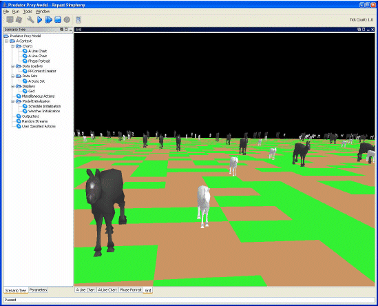 Whilst still being maintained RepastJ, Repast.Net and RepastPy have now reached maturity and are no longer being developed. They have been superseded by Repast Simphony (RepastS) which provides all the core functionality of RepastJ or Repast.Net, although limited to implementation in Java. The Repast development team have provided a series of articles regarding RepastS. The architecture and core functionality are introduced by North et al. (2005a), and the development environment is discussed by Howe et al. (2006). The storage, display and behaviour / interaction of agents, as well as features for data analysis (i.e. via the integration of the R statistics package) and presentation of models within Repast S are outlined by North et al. (2005b). Tatara et al. (2006) provide a detailed discussion outlining how-to develop a “simple wolf-sheep predation” model; illustrating RepastS modelling capabilities.
References:
Howe, T.R., Collier, N.T., North, M.J., Parker, M.T. and Vos, J.R. (2006), 'Containing Agents: Contexts, Projections, and Agents', Proceedings of Agent 2006 Conference on Social Agents: Results and Prospects, Chicago, USA.
North, M.J., Howe, T.R., Collier, N.T. and Vos, J.R. (2005a), 'The Repast Simphony Development Environment', Proceedings of the Agent 2005 Conference on Generative Social Processes, Models, and Mechanisms, Chicago, USA.
North, M.J., Howe, T.R., Collier, N.T. and Vos, J.R. (2005b), 'The Repast Simphony Runtime System', Proceedings of the Agent 2005 Conference on Generative Social Processes, Models, and Mechanisms, Chicago, USA.
Tatara, E., North, M.J., Howe, T.R., Collier, N.T. and Vos, J.R. (2006), 'An Introduction to Repast Simphony Modeling using a simple Predator-Prey Example', Proceedings of the Agent 2006 Conference on Social Agents: Results and Prospects, Chicago, USA.
Repast Simphony can be downloaded from the Repast website.
Tuesday, October 10, 2006
Principles and Concepts of Agent-Based Modelling for Developing Geospatial Simulations
 Christian and I have just finished writing a working paper entitled “Principles and Concepts of Agent-Based Modelling for Developing Geospatial Simulations”
The aim of this paper is to outline fundamental concepts and principles of the Agent-Based Modelling (ABM) paradigm, with particular reference to the development of geospatial simulations. The paper begins with a brief definition of modelling, followed by a classification of model types, and a comment regarding a shift (in certain circumstances) towards modelling systems at the individual-level. In particular, automata approaches (e.g. Cellular Automata, CA, and ABM) have been particularly popular, with ABM moving to the fore. A definition of agents and agent-based models is given; identifying their advantages and disadvantages, especially in relation to geospatial modelling. The potential use of agent-based models is discussed, and how-to instructions for developing an agent-based model are provided. Types of simulation / modelling systems available for ABM are defined, supplemented with criteria to consider before choosing a particular system for a modelling endeavour. Information pertaining to a selection of simulation / modelling systems (Swarm, MASON, Repast, StarLogo, NetLogo, OBEUS, AgentSheets and AnyLogic) is provided, categorised by their licensing policy (open source, shareware / freeware and proprietary systems). The evaluation (i.e. verification, calibration, validation and analysis) of agent-based models and their output is examined, and noteworthy applications are discussed.
Geographical Information Systems (GIS) are a particularly useful medium for representing model input and output of a geospatial nature. However, GIS are not well suited to dynamic modelling (e.g. ABM). In particular, problems of representing time and change within GIS are highlighted. Consequently, this paper explores the opportunity of linking (through coupling or integration / embedding) a GIS with a simulation / modelling system purposely built, and therefore better suited to supporting the requirements of ABM. This paper concludes with a synthesis of the discussion that has proceeded.
Key Words: Agent-Based Modelling (ABM), agent-based models, geospatial / spatially explicit modelling, verification, calibration, validation, Geographical Information Systems (GIS), linkage (coupling or embedding / integration).
The RedfishGroup
Santa Fe on Fire:
 Santa Fe on Fire: Agent-based modelling of wildfire evacuation dynamics was presented by Stephen Guerin at Agent 2006. The project for the City of Santa Fire Department integrating wildfire simulation and ABM of traffic dynamics. ArcGIS was used for preparing the data sources, NetLogo was used for prototyping the wildfire models and the network-based traffic models along with using FARSITE and Blender3D for further model development. Results from the model where outputted to Google Earth and QuickTime.
The Pittsburgh project explored Crowd Dynamics with an Agent-Based Model, and used to study evacuation from the Baseball Stadium. For example modelling the emergency scenario involving a bomb exploding in seats and subsequent disaster scenes that the explosion triggered inside and outside the ballpark.
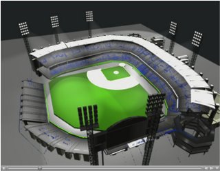 The projects listed also have the added advantage of sharing their source code, which I personally believe is really great, as it allows others to learn. The ability to carry out ABM in a highly visual and interactive manor allows the modellers to communicate ideas and theory to the public. For example in the case of Santa Fe on Fire, the visualisations evacuation dynamics were used to communicate with citizens dangers faced during evacuations and to explore when shelter-in-place is a reasonable alternative to evacuation.
Wednesday, September 27, 2006
Repasts Raster GIS and Sugar Scape models
 Following on from Christians ‘How to create a .pgm file from an .ascii file’ post I thought it would be useful to provide some models that show how this type of information can be loaded into Repast. Repast provides two models that use images that to create the basis of artificial worlds: the Sugar Scape model and a GIS Model (based on Raster data)
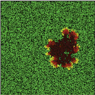
The GIS Model (top image), uses the RasterSpace class and reads in a .txt file (e.g. an .ascii file that can be outputted from ESRI ArcGIS. While the Sugar Scape Model (bottom image)reads in a .pgm file to great a Object2Dtorus space

The original source code for both models can be accessed through the RepastJ download. Alternatively, one can run the Sugar Scape or GIS Model by clicking these links (sorry these models will only run on a windows operating system)
Tuesday, September 26, 2006
Talks
 Life has been quite hectic for the last couple of weeks. We just come back from Chicago where we attended the Repast Training workshop which introduced us to Repast symphony (which looked quite cool) along with both presenting our work at the Agent 2006 Conference. I gave a paper titled “Exploring Cities Using Agent-based Models and GIS” and Christian’s paper was called “Using Repast to Develop a Prototype Agent-based Pedestrian Evacuation Model.” These papers will be available for download from the agent 2006 website soon.
 This week Christian and I are off to Oxford to present at a workshop called: Complexity and Dynamics: Volatility & Stability in City & Regional Systems, which is part of the European Conference on Complex Systems 2006. The workshop focuses on urban dynamics, along with volatility and stability in city and regional systems. Our paper is entitled “From Pedestrians to Cities: Exploring Urban Systems through Agent-Based Modelling”
PLAN C
New York University Bioinformatics group are using Repast to develop a agent based model simulation framework able to simulate the emergency responses in urban settings entitled PlanC. Catastrophic scenarios simulated include bomb explosion, the spread of small pox and food poisoning. The tool is intended to devise plans (such as time to recovery) for such scenarios based on the modelling of a large number of individual agents. The Models incorporate GIS data with agent based modelling (utilizing Repast)

Further reading/references such as the study of food poisoning in Brazil, or a hypothetical Sarin attack within Manhattan can be seen on the project website, along with a software demo. The site also claims the software will be available soon.
Friday, August 25, 2006
Slowing Repast simulations
 Occasionally, one might want to slow a Repast simulation, say to observe change within your model at a slower pace. There is no built in functionality in Repast to do this. However slowing a simulation down can be achieved using the Tread.sleep comand in the model code. This comand slows (stalls) the program for a specific period of time
You could put this code in your model's stepping function (the function called every 'tick'), or some other place that would be called whenever an action occurs. The argument to sleep is the number of milliseconds you would like your program to sleep. See the Repast emailing list comment by Vos for futher information.
public void step() {
// do normal functionality in step
try {Thread.sleep(100); // sleep a tenth of a second
} catch (Exception ex) {
// ignore this exception
}
}
Alternativly one could alter the speed of the simulation durring the model run eg:
public void step() {
// Pause the simulation according the selected speed
if(simulationSpeed <100){
try {
Thread.sleep(10 * (100 - simulationSpeed));
} catch (InterruptedException e) {
}
}
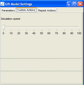
To hava an adjustable simulation speed, you may want to create say a slider (as the picture shows). To do this include the following bit of code in this in the setup() method:
public void setup(){
// Adjust the simulation speed durring the model run
class SimulationSpeedListener extends SliderListener {
public void execute() {
simulationSpeed = value;
}
}
modelManipulator.addSlider("Simulation speed", 0, 100, 10, new SimulationSpeedListener());
}
Where simulationSpeed refers to a int set in the main program.
Tuesday, August 22, 2006
Regional Science
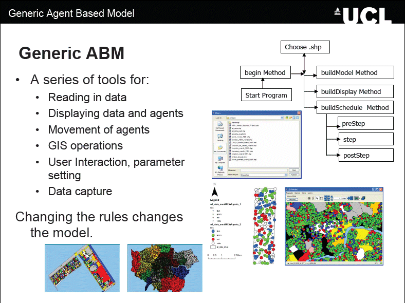 Cities are faced with many problems such as urban sprawl, congestion, crime, segregation, etc. They are also constantly changing. Computer modelling is becoming an increasingly important tool when examining how cities operate. Agent-Based Models (ABM) provide an environment to test different hypotheses and theories to urban change based on the individual behaviours of agents, thus leading to a greater understanding of how cities work.
This paper presents the development of generic agent-based simulation model for the examination of urban issues focusing on the integration of Geographical Information Systems (GIS) and ABM where space plays a central role, for past ABM have been criticised for not being spatial as they have been developed outside geography in other social sciences (Torrens 2003). The model allows for global patterns emerging from local interactions of individual agents. Using the generic framework, models can be developed rapidly to examine urban issues. One of the types of models will be presented: a segregation model. The model was created with only minor alterations to the basic model structure, highlighting how this approach can be applied to different styles of urban models.
Batty et al. (2004) write that it is hard to find clear examples of segregation process taking place, because it only becomes noticeable when it is clearly underway, and by then a detailed chronology becomes impossible to reconstruct. Schelling (1969) presented a model on the emergence of segregation where he showed that with mild preferences to locate amongst like demographic or economic activity groups, strict segregation would emerge unknowingly. This segregation is all too clear when one walks around the urban area, there are clusters of economic groups and residential groups based on ethnicity or social class.
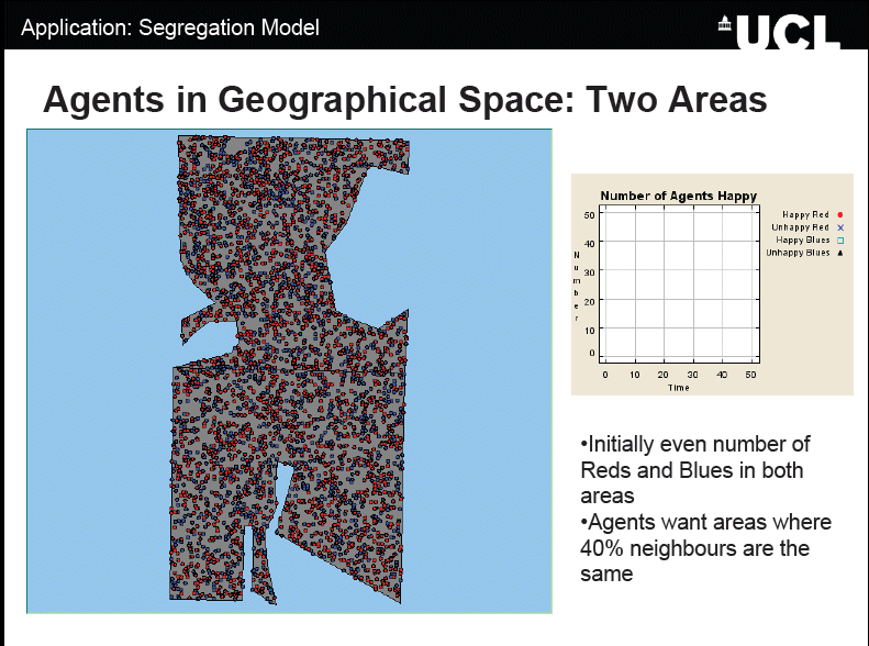 To highlight this idea of segregation based on simple tastes and preferences, a simple segregation model has been created inheriting much of the features from the generic model. Individuals are given the same initial starting conditions but different preferences for their neighbours. What is clear is that with different percentages of similarity wanted, different patterns will emerge. However these patterns change as time passes, as the agents move to find areas in which they are happy to live in, thus changing the composition of the neighbourhood and the overall appearance of the system. Unlike the traditional segregation models, space is not restricted to discrete homogenous cells, more than one agent is allowed per area, and more intelligent movement, and searching mechanisms are introduced (e.g. agents don’t just move to random locations or the nearest empty cell). System dynamics are introduced with agents entering and leaving the system. To conclude the paper will present future avenues of research.
The PowerPoint of the talk can be downloaded from here:
Wednesday, August 9, 2006
How to create a .pgm file from an .ascii file
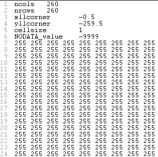
This may seem far fetch, but this situation can arise. For example, Figure 1 is a .shapefile of a building floor plan. This was converted from ‘feature to raster’ using ESRI’s ArcToolbox so the ABM could use the underlying cell values to dictate the movement of the agents (Figure 2). Unfortunately, the raster file can only be exported as an .ascii file from ArcGIS. Figure 3 is a screen capture of the file viewed as text. However, the file can be converted by altering the header in Figure 3 to the header in Figure 4, and changing the file extension from .ascii to .pgm. The value ‘P2’ in the first line is always required, and ‘260’ and ‘260’ refer to the number of columns and rows, while the value in the third line refers to the highest value within the file (for scaling the values to be displayed). The third row should be set as either: 1, 3, 7, 15, 31, 63, 127, or 255. If this value is set considerably larger than the highest value within the file there will be less differential between the values (in terms of grey) to be displayed, and this may result in the image appearing as completely black.



Thursday, August 3, 2006
Repast Models of the Week:The SLUDGE and SluGIS models
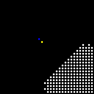 The SLUDGE model (Simulated Land Use Dependent on Edge Effect Externalities) was developed by Dawn Parker. The combines a simple cellular automaton and agent-based model which was designed to study the joint influence of distance-dependent spatial externalities and transportation costs on patterns of land use. Further information on her work can be found at discussed in the following papers:
Parker, D. C. 1999. "Landscape Outcomes in a Model of Edge-Effect Externalities: A Computational Economics Approach", Santa Fe, NM: Santa Fe Institute Publication 99-07-051 E.
Parker and Meretsky, 2004, "Measuring Pattern Outcomes in an Agent-Based Model of Edge-Effect Externalities Using Spatial Metrics"; Agriculture, Ecosystems, and Environment 101:233-250.
A Repast model of SLUDGE has also been programmed by Robert Najlis. The source code for the original model can be downloaded from here. Alternatively if you viewing this post on a computer using windows, you can run the model directly by clicking here.

Robert Najlis has also developed a model called SluGIS which is a closely-related model of of SLUDGE. With the major distinction as it is a move away from the cellular space used in the previous model. SluGIS runs on a vector landscape. Robert Najlis has used Repast GIS functionally (and produced the same model both ESRIs and OpenMap interfaces of Repast).
A modified OpenMap version can be run by downloading the following and unzipping the following Shapefile package (download Shapefiles) and storing it to disk. Then by running the model by clicking here and choosing the shapefile you just saved to disk.
The original java files for the OpenMap and ESRI SluGIS models can be found here. A modified ESRI version which was created by Michael Leamy can be downloaded from here. All that needs to be done is to change the path names for the .shp file, the .gal file, and the refresh call. Look for this in SluGISEsri.java.
For more information on Repast GIS see the Repast website “How to use GIS data with Repast”.
Tuesday, June 27, 2006
Repast Model of the week: jEcho
 jECHO, created by Brian McIndoe is a new version of the ECHO model of a Complex Adaptive System (CAS) described by Holland using Repast. The aim of the research was to seek insights into CAS behavior in an attempt to evaluate ECHO model mechanisms and properties.
Further information
Brian McIndoe site also contains a copy of the Masters dissertation which describes the analysis, design and implementation of jECHO plus some experimentation and references.
The original source code for the model can be found and downloaded by clicking here
Alternatively, to run a verision of the model click here (Sorry it will only work in Windows). For instructions on how to run a Repast model see the Repast website.
Friday, June 23, 2006
Repast Model of the Week: Repast 2D Model Template
About the model
This specific model is just a set of agents that take random walks on a space which has been initialized to have areas that are not penetrable (Green Area). The two rules are that agents can't occupy the same location in the space at the same time (i.e. one agent per cell), and they can't invade any blocked areas of the space. As the agents wander they leave a trace in the space so we can see that, as Random Walk theory posits, they do indeed cover all the territory (areas becoming grey).
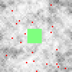 Figure showing the agents (red dots), the not penetrable areas (Green Area) and the space (white through to grey for the most walked areas)
The mode also utilizes Repasts Graphing functions. There are Graph and Histogram windows that plot some internal agent values. The Graph shows the total number of collisions over time, and the Histogram shows the distribution of move-directions for each step. They are examples of use, more than useful examples.
The model can also log data from each step to a file named Template_data.txt. This uses Repasts DataRecorder class. Checking the writelog entry in the Settings window before starting a run will enable the log. Again this is more for illustrative purposes than to provide useful data.
Further information about the model can be found here, which includes the source code and more details about the model. To run an executable of the model (if you are using a windows machine) click here.
Tuesday, June 20, 2006
Repast Model of the week: EvoTech model
 Figure is Part of the frameset of the simulation model. It shows population numbers, surviving phenotypes, and their distribution.
Wednesday, June 14, 2006
GAL Files
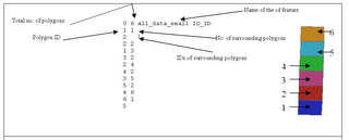
An annotated example of a .GAL file and the associated shapefile with the polygons numbered accordingly.
Sunday, May 28, 2006
Publications
Journal Articles (†Denotes graduate student collaborator) (19 in Total) |
|
| 1. | †Mullen W., †Jackson, S. P., Croitoru, A., Crooks, A. T., Stefanidis, A. and Agouris, P., (accepted), Assessing the Impact of Demographic Characteristics on Spatial Error in Volunteered Geographic Information Features, GeoJournal. (pdf) |
| 2. | Crooks, A.T., †Masad, D., Croitoru, A., †Cotnoir, A., Stefanidis, A. and †Radzikowski, J. (2014), International Relations: State-Driven and Citizen-Driven Networks, Social Science Computer Review, 32(2): 205-220. (pdf) |
| 3. | Patel, A., Koizumi, N. and Crooks, A.T. (2014), Measuring Slum Severity in Mumbai and Kolkata: A Household-based Approach, Habitat International, 41: 300-306. (pdf) |
| 4. | Croitoru, A., Crooks, A.T., †Radzikowski, J. and Stefanidis, A. (2013), GeoSocial Gauge: A System Prototype for Knowledge Discovery from Social Media, International Journal of Geographical Information Science, 27 (12): 2483-2508. (pdf) |
| 5. | Crooks, A.T. and †Wise, S. (2013), GIS and Agent-Based models for Humanitarian Assistance, Computers, Environment and Urban Systems, 41: 100-111. (pdf) |
| 6. | †Jackson, S. P., †Mullen W., Agouris, P., Crooks, A. T., Croitoru, A. and Stefanidis, A. (2013), Assessing Completeness and Spatial Error of Features in Volunteered Geographic Information, ISPRS International Journal of Geo-Information, 2 (2): 507-530. (pdf) |
| 7. | Stefanidis, A., †Cotnoir, A., Croitoru, A., Crooks, A.T., †Radzikowski, J. and Rice, M. (2013), Demarcating New Boundaries: Mapping Virtual Polycentric Communities through Social Media Content, Cartography and Geographic Information Science, 40(2): 116-129. (pdf) |
| 8. | Stefanidis, T., Crooks, A.T. and †Radzikowski, J. (2013), Harvesting Ambient Geospatial Information from Social Media Feeds, GeoJournal 78, (2): 319-338. (pdf) |
| 9. | Crooks, A.T., Croitoru, A., Stefanidis, A. and †Radzikowski, J. (2013), #Earthquake: Twitter as a Distributed Sensor System, Transactions in GIS, 17(1): 124-147. (pdf) |
| 10. | †Wise, S. and Crooks, A.T. (2012), Agent Based Modelling and GIS for Community Resource Management: Acequia-based Agriculture, Computers, Environment and Urban Systems, 36(6): 562-572. (pdf) |
| 11. | †Patel, A., Crooks, A.T. and Koizumi, N. (2012), Slumulation: an Agent-based Modeling Approach to Slum Formations, Journal of Artificial Societies and Social Simulation, 15 (4). Available at http://jasss.soc.surrey.ac.uk/15/4/2.html (pdf) |
| 12. | Crooks, A.T. (2010), Constructing and Implementing an Agent-Based Model of Residential Segregation through Vector GIS, International Journal of Geographical Information Science, 24(5): 661-675. (pdf) |
| 13. | Batty, M., Hudson-Smith, A., Milton, R. and Crooks, A. T. (2010), Map MashUps, Web 2.0 and the GIS Revolution, Annals of GIS, 16(1): 1-13. (pdf) |
| 14. | Crooks, A. T., Hudson-Smith, A., and Dearden, J. (2009), Agent Street: An Environment for Exploring Agent-Based Models in Second Life, Journal of Artificial Societies and Social Simulation, 12 (4). Available at http://jasss.soc.surrey.ac.uk/12/4/10.html (pdf) |
| 15. | Hudson-Smith, A., Crooks, A.T., Gibin, M., Milton, R., and Batty, M. (2009), Neogeography and Web 2.0: Concepts, Tools and Applications, Journal of Location Based Services, 3(2) 118 - 145. (pdf) |
| 16. | Masucci, A. P., Smith, D., Crooks, A.T. and Batty, M. (2009) Random Planar Graphs and the London Street Network, The European Physical Journal B, 71 (2): 259-271. (pdf) |
| 17. | Hudson-Smith, A., Batty, M., Crooks, A.T., and Milton R. (2009), Mapping Tools for the Masses: Web 2.0 and Crowdsourcing, Social Science Computer Review, 27 (4): 524-538. (pdf) |
| 18. | Hudson-Smith, A. and Crooks, A. T. (2008), Building Space in the Machine: Digital Tool Kits for Mirror Worlds, AGORA: Dutch Journal for Social-Spatial Questions, 2008(4): 27-29. (pdf) |
| 19. | Crooks, A.T., Castle, C. J. E., and Batty, M. (2008), Key Challenges in Agent-Based Modelling for Geo-spatial Simulation, Computers, Environment and Urban Systems, 32(6): 417-430. (pdf) |
| Impact Factors: JASSS: 1.733; CEUS: 1.674; ; IJGIS: 1.6613; HI: 1.418; SSCR: 1.303; EPJ B: 1.282; TGIS 0.906; CAGIS: 0.611. | |
| Edited Book (1 in Total) | |
| 20. | Heppenstall, A., Crooks, A. T., See, L.M., and Batty, M. (eds.)(2012) Agent-based Models of Geographical Systems. Springer, New York, NY. (pdf) |
| Book Chapters (15 in Total) | |
| 21. | Croitoru, A., Crooks, A.T., †Radzikowski, J. and Stefanidis, A. (accepted), Geovisualization of Social Media, in Richardson, D., Castree, N., Goodchild, M. F., Kobayashi, A. L., Liu, W. and Marston, R. (eds.), The International Encyclopedia of Geography: People, the Earth, Environment, and Technology, Wiley Blackwell. (pdf) |
| 22. | Crooks, A.T. (accepted), Agent-based Models and Geographical Information Systems, in Brunsdon, C. and Singleton, A. (eds.), Geocomputation: A Practical Primer, Sage. (pdf) |
| 23. | Stefanidis, A., Crooks, A.T., † Radzikowski, J., Croitoru, A. and Rice, M. (2014), Social Media and the Emergence of Open-Source Geospatial Intelligence, in Murdock, D.G., Tomes, R. and Tucker, C. (eds.), Human Geography: Socio-Cultural Dynamics and Global Security, US Geospatial Intelligence Foundation (USGIF), Herndon, VA, pp. 109-123. (pdf) |
| 24. | Crooks, A.T., Patel, A. and †Wise, S. (2014), Multi-agent Systems for Urban Planning, in Pinto, N.N., Tenedório, J. Antunes A. P. and Roca, J. (eds.), Technologies for Urban and Spatial Planning: Virtual Cities and Territories, IGI Global, Hershey, PA, pp. 29-56. (pdf) |
| 25. | Crooks, A.T., Hudson-Smith, A., Croitoru, A. and Stefanidis, A. (2014), The Evolving GeoWeb, in Abrahart R. J. and See, L. M. (eds.), Geocomputation (Second Edition), CRC Press, Boca Raton, FL, pp. 69-96. (pdf) |
| 26. | Croitoru, A., Crooks, A.T., Radzikowski, J., Stefanidis, A., Vatsavai, R. R. and Wayant, N. (2014), Geoinformatics and Social Media: A New Big Data Challenge, in Karimi, H. (ed.), Big Data Techniques and Technologies in Geoinformatics. CRC Press, Boca Raton, FL, pp. 207-232. (pdf) |
| 27. | Crooks, A. T. (2012), The Use of Agent-Based Modelling for Studying the Social and Physical Environment of Cities, in De Roo, G, Hiller, J. and Van Wezemael, J. (eds.), Complexity and Planning: Systems, Assemblages and Simulations, Ashgate, Burlington, VT, pp. 385-408. (pdf) |
| 28. | Crooks, A.T. and Castle, C. (2012), The Integration of Agent-Based Modelling and Geographical Information for Geospatial Simulation, in Heppenstall, A.J., Crooks, A.T., See, L.M. and Batty, M. (eds.), Agent-based Models of Geographical Systems, Springer, New York, NY, pp. 219-252.(pdf) |
| 29. | Crooks, A.T. and Heppenstall, A.J. (2012), Introduction to Agent-based Modelling, in Heppenstall, A.J., Crooks, A.T., See, L.M. and Batty, M. (eds.), Agent-based Models of Geographical Systems, Springer, New York, NY, pp. 85-108. (pdf) |
| 30. | Batty, M., Crooks, A. T., See, L. M. and Heppenstall, A. J. (2012), Perspectives on Agent-Based Models and Geographical Systems, in Heppenstall, A.J., Crooks, A.T., See, L.M. and Batty, M. (eds.), Agent-based Models of Geographical Systems, Springer, New York, NY, pp. 1-18. (pdf) |
| 31. | Heppenstall, A.J., Crooks, A.T., See, L.M. and Batty, M. (2012), Reflections and Conclusions: Geographical Models to Address Grand Challenges, in Heppenstall, A.J., Crooks, A.T., See, L.M. and Batty, M. (eds.), Agent-based Models of Geographical Systems, Springer, New York, NY, pp. 739-748. (pdf) |
| 32. | Crooks, A. T., Hudson-Smith, A. and Patel, A. (2011), Advances and Techniques for Building 3D Agent-Based Models for Urban Systems, in Marceau D. and Benenson, I. (eds.), Advanced Geosimulation Models, Bentham Science Publishers, Hilversum, The Netherlands, pp 49-65.(pdf) |
| 33. | Hudson-Smith, A., Batty, M., Crooks, A. T., and Milton R. (2010) Neogeography and the Power of the Crowd: Networks and Map Hacks, in Madhuri, V. (ed.) User Generated Content: Regulatory Dimensions, Amicus Books, Hyderabad, India, pp 122-147. (pdf) |
| 34. | Hudson-Smith, A. and Crooks, A. T. (2009), The Renaissance of Geographic Information: Neogeography, Gaming and Second Life, in Lin, H. and Batty, M. (eds.), Virtual Geographic Environments, Science Press, Beijing, PRC, pp 25-36. Reprinted by ESRI Press 2011. (pdf) |
| 35. |
Castle, C. J. E., Crooks, A. T.,
de Smith, M. J., Goodchild, M. F., and Longley, P. A. (2007),
Geocomputational Methods and Modelling, in de Smith, M. J., Goodchild,
M. F., and Longley, P. A. (eds.), Geospatial Analysis: A Comprehensive Guide to Principles, Techniques and Software Tools (2nd Edition), The Winchelsea Press, Winchelsea, UK, pp 383-450 ( subsequently extended in the 3rd
Edition pp. 445-519). (web version)
|
| Papers Under Review (6 in Total) | |
| 36. | Crooks, A.T. and Hailegiorgis, A.B. (under review), An Agent-based Modeling Approach Applied to the Spread of Cholera, Environmental Modelling & Software. (pdf) |
| 37. | Crooks, A.T., Pfoser, D., †Jenkins, A., Croitoru, A., Karagiorgou, S., Efentakis, A., Lamprianidis, G., Smith, D. and Stefanidis, A. (under review), Crowdsourcing Urban Form and Function, International Journal of Geographical Information Science. (pdf) |
| 38. | †Malik, A.A., Crooks, A.T., Root, H.L. and †Swartz, M. (under review), Exploring Creativity and Urban Development through Agent-Based Modeling, Journal of Artificial Societies and Social Simulation. (pdf) |
| 39. | Croitoru, A., Wayant, N., Crooks, A.T., †Radzikowski, J. and Stefanidis, A. (under review), Linking Cyber and Physical Spaces Through Community Detection And Clustering in Social Media Feeds, Computers, Environment and Urban Systems. (pdf) |
| 40. | †Panteras, G., †Wise, S., †Lu, X., Croitoru, A., Crooks, A.T. and Stefanidis, A. (under review), Triangulating Social Multimedia Content for Event Localization using Flickr and Twitter, Transactions in GIS. (pdf) |
| 41. | Crooks, A.T. (under review), Cellular Automata, in Richardson, D., Castree, N., Goodchild, M. F., Kobayashi, A. L., Liu, W. and Marston, R. (eds.), The International Encyclopedia of Geography: People, the Earth, Environment, and Technology, Wiley Blackwell. (pdf) |
| Book Reviews (4 in Total) | |
| 42. | Crooks, A.T. (2013), Crooks on Steinitz: A Framework for Geodesign: Changing Geography by Design, Environment and Planning B, 40 (6): 1122-1124. (pdf) |
| 43. | Crooks, A.T. (2012), Crooks on Koch and Mandl (eds.): Modeling and Simulating Urban Processes, Journal of Artificial Societies and Social Simulation, 14(4). Available at: http://jasss.soc.surrey.ac.uk/15/4/reviews/1.html. (pdf) |
| 44. | Crooks, A. T. (2010), Crooks on Albeverio, Andrey, Giordano and Vancheri (eds.): The Dynamics of Complex Urban Systems: An Interdisciplinary Approach, Applied Spatial Analysis and Policy, 3(1): 75-7. (pdf) |
| 45. | Crooks, A. T. (2009), Crooks on Foth: Handbook of Research on Urban Informatics: The Practice and Promise of the Real-Time City, Environment and Planning B, 36 (5): 946-947. (pdf) |
| 46. |
Crooks, A. T. (2008),
Crooks on North, Macal: Managing Business Complexity: Discovering
Strategic Solutions with Agent-Based Modelling and Simulation, Crooks on
Rennard (ed.): Handbook of Research on Nature-Inspired Computing for
Economics and Management, Environment and Planning B, 35(6): 1117-1132. (pdf)
|
| Peer Reviewed Conference Papers/Presentations (*Denotes Speaker(s)) (23 in Total) | |
| 47. | *Crooks, A.T. and Hailegiorgis, A. (2013), Disease Modeling Within Refugee Camps: A Multi-agent Systems Approach, in Pasupathy, R., Kim, S.-H., Tolk, A., Hill, R. and Kuhl, M. E. (eds.), Proceedings of the 2013 Winter Simulation Conference, Washington, DC, pp 1697-1706. (pdf) |
| 48. | *†Lu, X., Croitoru, A., †Radzikowski, J, Crooks, A. T. and Stefanidis, A. (2013), Comparing the Spatial Characteristics of Corresponding Cyber and Physical Communities: A Case Study, 6th ACM SIGSPATIAL International Workshop on Location-Based Social Networks, Orlando, FL, pp 11-14. (pdf) |
| 49. | *Patel, A., Crooks, A. T. and Koizumi, N. (2012), Simulating Spatio-Temporal Dynamics of Slum Formation in Ahmedabad, India. 6th Urban Research and Knowledge Symposium - Rethinking Cities: Framing the Future, Barcelona, Spain. (pdf) |
| 50. | *Latek, M. M., Mussavi Rizi, S. M., Crooks, A. T. and Fraser, M. (2012), A Spatial Multiagent Model of Border Security for the Arizona-Sonora Borderland. The Computational Social Science Society of America Conference, Santa Fe, NM. (pdf) |
| 51. | *†Hailegiorgis, A. and Crooks, A.T. (2012), Agent-based Modeling for Humanitarian Issues: Disease and Refugee Camps. The Computational Social Science Society of America Conference, Santa Fe, NM. (pdf) |
| 52. | *Wayant, N., Crooks, A.T., Stefanidis, A., Croitoru, A., †Radzikowski, J., Stahl, J. and Shine, J. (2012), Spatiotemporal Clustering of Social Media Feeds for Activity Summarization, GI Science (7th International Conference for Geographical Information Science), Columbus, OH.(pdf) |
| 53. | *Latek, M. M., Mussavi Rizi, S. M., Crooks, A. T. and Fraser, M. (2012), Social Simulations for Border Security, Workshop on Innovation in Border Control 2012, Co-located with the European Intelligence and Security Informatics Conference (EISIC 2012), Odense, Denmark. (pdf) |
| 54. | Croitoru, A., Stefanidis, A., Radzikowski, J., Crooks, A. T., Stahl, J. and Wayant, N*. (2012), Towards a Collaborative GeoSocial Analysis Workbench. COM-Geo, Washington, DC. (pdf) |
| 55. | *Gulden, T., †Cotla, C. R., †Hailegiorgis, A. and Crooks, A.T. (2011), A Generic Vegetation Growth Sub-model in a Large Human/Environment Interaction Model of East Africa. The Computational Social Science Society of America Conference (2011), Santa Fe, NM. (pdf) |
| 56. | *Gulden, T., †Harrison, J. F. and Crooks, A.T. (2011), Modeling Cities and Displacement through an Agent-based Spatial Interaction Model. The Computational Social Science Society of America Conference (2011), Santa Fe, NM. (pdf) |
| 57. | *†Wise, S. and Crooks, A. T. (2011), Agent Based Modelling and GIS for Community Resource Management: Acequia-based Agriculture, Proceedings of the 11th International Conference on Geocomputation, University College London, London, England, pp 388-394.(pdf) |
| 58. | *Crooks, A. T. and †Wise, S. (2011), Modelling the Humanitarian Relief through Crowdsourcing, Volunteered Geographical Information and Agent-based Modelling: A test Case - Haiti, Proceedings of the 11th International Conference on Geocomputation, University College London, London, England, pp 183-187. (pdf) |
| 59. | *†Pint, B., Crooks, A. T., and Geller, A. (2010), An Agent-based Model of Organized Crime: Favelas and the Drug Trade. 2nd Brazilian Workshop on Social Simulation, Sao Bernardo do Campo, Brazil. (pdf) |
| 60. | †Rouly, O. V. and *Crooks, A. T. (2010), A Prototype, Multi-agent System for the Study of the Peopling of the Western Hemisphere, in Ernst, A. and Kuhn, S. (eds) Proceedings of the 3rd World Congress on Social Simulation (WCSS2010): Scientific Advances in Understanding Societal Processes and Dynamics, Kassel, Germany. (pdf) |
| 61. | *Hudson-Smith, A., M., Milton, R., Crooks, A. T. and Batty, M. (2009), Crowd Sourced Data for the Social Sciences: Web Based Services and Real-Time Geographic Surveys. 5th International Conference on e-Social Science, Cologne, Germany. (pdf) |
| 62. | *Crooks, A. T., Hudson-Smith, A., M., Milton, R., and Batty, M. (2009), Crowdsourcing Spatial Surveys and Mapping, in Fairbairn, D. (ed.), Proceedings of the 17th Geographical Information Systems Research UK Conference, Durham University, England, pp 263-269. (pdf) |
| 63. | *Slingsby, A., Dykes, J., Wood, J. and Crooks, A.T. (2009), The Role of Layout and Order in Treemaps for Showing Spatial and Temporal Variation in House Prices. GeoViz, Hamburg Germany. (pdf, website) |
| 64. | Crooks, A. T., *Smith, D. A., and Theseira, M. (2008), The Fine Scale Spatial Dynamics of the Greater London Housing Market, in Lambrick, D. (ed.), Proceedings of the 16th Geographical Information Systems Research UK Conference, UNIGIS, Manchester Metropolitan University, England, pp. 117-124. (pdf) |
| 65. |
*Crooks, A. T.,
Castle, C. J. E., and *Batty, M. (2007), Key Challenges in Agent-Based
Modelling for Geo-spatial Simulation, in Demšar, U (ed.), Proceedings of the 9th International Conference on Geocomputation, National Centre for Geocomputation, National University of Ireland, Maynooth, Ireland. (pdf)
|
| 66. |
Crooks, A. T. (2006), Exploring Cities Using Agent-Based Models and GIS, Proceedings of the Agent 2006 Conference on Social Agents: Results and Prospects, University of Chicago and Argonne National Laboratory, Chicago, IL. (pdf)
|
| 67. | Crooks, A. T. (2006), Experimenting with Cities Using Agent Based Models, in Priestnall, G., and Aplin, P. (eds.), Proceedings of the 14th Geographical Information Systems Research UK Conference, The University of Nottingham, England, pp. 240-243. (pdf) |
| 68. | Castle, C. J. E., Crooks, A. T., *Longley, P.A., and Batty, M. (2006), Agent-Based Modelling and Simulation using Repast: A Gallery of GIS Applications from CASA, in Priestnall, G., and Aplin, P. (eds.), Proceedings of the 14th Geographical Information Systems Research UK Conference, The University of Nottingham, England, pp. 237-239. (pdf) |
| 69. | *Theseira, M. and Crooks, A. T. (2005), The Relationship between Population, Employment and Accessibility in London, in Billen, R., Drummond, J., Forrest, D., and Joao, E. (eds.), Proceedings of the 13th Geographical Information Systems Research UK Conference, University of Glasgow, Scotland, pp. 169-174. (pdf) |
| Invited Presentations (18 in Total) | |
| 70. | Crooks, A.T. (2014), GeoSocial Analysis: From Natural Disasters to Protests, Department of Geographical Sciences, University of Maryland in College Park, 17th April, College Park, MD. (pdf) |
| 71. | *Crooks, A.T., *An, L., *Metcalf, S., *Magliocca, N. and *Zellner M.P. (2014), How Can We Make Agent-based Models More Relevant?, Panel Session, The Association of American Geographers (AAG) Annual Meeting, 11th April, 2013, Tampa, FL. (pdf) |
| 72. | Crooks, A.T. (2014), Disasters and Diseases: An Agent-based Modeling Perspective, Department of Geography and GeoInformation Science (GGS 759- Topics in Earth Systems Science), George Mason University, 11th February, Fairfax, VA. (pdf) |
| 73. | Crooks, A.T. (2013), Agent-based Models for Humanitarian Assistance and Diseases, Department of Global And Community Health (GCH 605 - Social Epidemiology), George Mason University, 19th November, Fairfax, VA. |
| 74. | Crooks, A.T. (2013), Computational Social Science and Geographic Information, Department of Geography and GeoInformation Science, (GGS 759 - Topics in Earth Systems Science), George Mason University, 23rd April, Fairfax, VA. |
| 75. | Crooks, A.T. (2012), Geosocial Analysis for Urban Operations, The Science and Technology Board (STB) Symposium on Science and Technology for Urban Operations, 10th September, Norfolk, VA. (pdf) |
| 76. | Crooks, A. T. (2012), Pedestrians to Cities with Agent-Based Modeling and GIS, Geometry, Graphics, Robotics, AI, Algorithms, and Data Mining (GRAND) Seminar Series, Department of Computer Science, George Mason University, 3rd April, Fairfax, VA. |
| 77. | Crooks, A. T. (2012), Pedestrians to Cities with Agent-Based Modeling and GIS, National Geospatial Intelligence Agency (NGA), 6th March, Springfield, VA. (pdf) |
| 78. | Crooks, A. T. (2011), Agent-based Modeling, GGS 684: Select Topics in Geospatial Intelligence, US Army Corps of Engineers Geospatial Center, 7th and 16th June, Alexandria, VA. |
| 79. | Crooks, A. T. (2011), Spatial Agent-based Modeling, Department of Geography and GeoInformation Science, GGS 684: Select Topics in Geospatial Intelligence, George Mason University, 21st April, Fairfax, VA. |
| 80. | Crooks, A. T. (2011), Social Network Analysis and Geography, Department of Computational Social Science, (CSS 692: Social Network Analysis), George Mason University, 19th April, Fairfax, VA. |
| 81. | Crooks, A. T. (2011), Agents in the City: Modeling, Visualizing, and Communicating Emergent Phenomena Utilizing GIS and Agent-Based Modeling, Center for Urban Environmental Research and Education, University of Maryland, Baltimore County, 4th March, Baltimore, MD. (pdf) |
| 82. | Crooks, A. T. and Latek, M.M. (2011), Use of Agent Based Modeling on Transportation and Health, School of Public Policy, (PUBP714-002/003: Transportation and Health), George Mason University, 2nd March, Arlington, VA. |
| 83. | Torrens, P., Crooks, A. T. and Guerin, S. (2010), The Exultation and Agony of Combining GIS and ABM Panel, 2010 Computational Social Science Society Conference, 5th - 6th November, Tempe, AZ. |
| 84. | Crooks, A. T. (2010), GIS and Agent-based Modeling, NGA funded Mentor Protégé Program: Northrop Grumman - CSSS Yr 4 Training Workshop, School of Public Policy, George Mason University, 3rd September, Arlington, VA. |
| 85. |
Crooks, A. T. (2006) Social Science Applications Utilising GIS at the Centre for Advanced Spatial Analysis, Innovative methods Seminar: the role of Geographic Information Systems (GIS) in Government Social Research. Scottish Executive, 15th November, Edinburgh, Scotland. Keynote speaker. (pdf)
|
| 86. |
Crooks, A. T. (2006), Understanding how Cities Work - Using Agent-Based Modelling to Simulate Urban Change, London and the Local Economy, Greater London Authority Economics Unit Seminar, 1st June, London, England. (pdf)
|
| Working Papers & Technical Reports | |
| 87. | †Malik, A.A., Crooks, A.T.
and Root, H.L. (2013), Can Pakistan have Creative Cities? An Agent Based
Modeling Approach with Preliminary Application to Karachi. Pakistan Strategy Support Program Working Paper 13, International Food Policy Research Institute (IFPRI), Washington, DC. (pdf) |
| 88. |
Crooks, A. T., Hudson-Smith, A. and Patel, A. (2010), Building 3D Agent-Based Models for Urban Systems. Centre for Advanced Spatial Analysis (University College London): Working Paper 161, London, England. (pdf)
|
| 89. |
Crooks, A. T. (2010), Using Geo-spatial Agent-Based Models for Studying Cities. Centre for Advanced Spatial Analysis (University College London): Working Paper 160, London, England.(pdf)
|
| 90. | Anand, S., Batty, M., Crooks, A. T., Hudson-Smith, A., Jackson, M., Milton, R. and Morley, J. (2010), Data Mash-ups and the Future of Mapping. Joint Information Systems Committee (JISC) Technology and Standards Watch (TechWatch) Horizon Scanning report 10_01, Bristol, England. (pdf) (Commissioned and peer reviewed) |
| 91. |
Smith, D. A. and Crooks, A. T.
(2010), From Buildings to Cities: Enabling the Multi-Scale Analysis of
Urban Form and Function through the integration of Geographical and
Geometric Methods. Centre for Advanced Spatial Analysis (University College London): Working Paper 155, London, England. (pdf)
|
| 92. | Masucci, A. P., Smith, D., Crooks, A. T. and Batty, M. (2009) Random Planar Graphs and the London Street Network, Centre for Advanced Spatial Analysis (University College London): Working Paper 146, London, England. (pdf) |
| 93. | Hudson-Smith, A., Batty, M., Crooks, A. T., and Milton, R. (2008), Mapping for the Masses: Accessing Web 2.0 through Crowdsourcing, Centre for Advanced Spatial Analysis (University College London): Working Paper 143, London, England. (pdf) |
| 94. | Hudson-Smith, A. and Crooks, A. T. (2008), The Renaissance of Geographic Information: Neogeography, Gaming and Second Life, Centre for Advanced Spatial Analysis (University College London): Working Paper 142, London, England. (pdf) |
| 95. | Crooks, A. T. (2008), Constructing and Implementing an Agent-Based Model of Residential Segregation through Vector GIS, Centre for Advanced Spatial Analysis (University College London): Working Paper 133, London, England. (pdf) |
| 96. |
Crooks, A. T. (2007), Experimenting with Cities: Utilizing Agent-Based Models and GIS to Explore Urban Dynamics, PhD Thesis, University College London, London, England. (pdf)
|
| 97. |
Crooks, A. T. (2007), The Repast Simulation/Modelling System for Geospatial Simulation, Centre for Advanced Spatial Analysis (University College London): Working Paper 123, London, England. (pdf)
|
| 98. | Crooks, A. T., Castle, C. J. E. and Batty, M. (2007), Key Challenges in Agent-Based Modelling for Geo-Spatial Simulation, Centre for Advanced Spatial Analysis (University College London): Working Paper 121, London, England. (pdf) |
| 99. |
Castle, C. J. E. and Crooks, A. T. (2006), Principles and Concepts of Agent-Based Modelling for Developing Geospatial Simulations, Centre for Advanced Spatial Analysis (University College London): Working Paper 110, London, England. (pdf)
|
| 100. | Crooks, A. T. (2006), Exploring Cities Using Agent-Based Models and GIS, Centre for Advanced Spatial Analysis (University College London): Working Paper 109, London, England. (pdf) |
| 101. | Crooks, A. T. (2002), Mapping out the Future: Extending the Mapping Capabilities of the Gazetteer for Scotland, MSc Thesis, University of Edinburgh, Edinburgh, Scotland. (pdf) |
| Other Presentations/Conferences (42 in Total) | |
| 102. | *Crooks, A.T. and †Chopra, P. (2014), An Agent-based Model for the Spread and Containment of Tuberculosis, The Association of American Geographers (AAG) Annual Meeting, 8th-12th April, 2013, Tampa, FL. (pdf) |
| 103. | *†Malik, A., †Swartz, M., Crooks, A.T. and Root, H. (2013), Agent-Based Modeling Simulations for Solving Pakistan’s Urban Challenge, SWARMFEST 2013: 17th Annual Swarmfest Conference, 8th-9th July, Orlando, FL. (pdf) |
| 104. | *†Malik, A., †Swartz, M., Root, H. and Crooks, A.T. (2013), Creative Karachi: Using Agent-Based Models to Explore Pakistan’s Urban Challenges and Opportunities, The 6th Annual Experience the Creative Economy Conference, 18th-21st June, Toronto, Canada. (pdf) |
| 105. |
*Patel, A., Crooks, A.T. and Koizumi, N. (2013), A Spatial ABM Approach to Explore Slum Formation Dynamics in Ahmedabad, India, The Association of American Geographers (AAG) Annual Meeting, 9th -13th April, Los Angeles, CA. (pdf)
|
| 106. | *†Pint, B. and Crooks, A.T. (2013), The Impact of a Slum's Social Dynamics and Geospatial Landscape on the Emergence of Riots: The Case of Kibera, The Association of American Geographers (AAG) Annual Meeting, 9th -13th April, Los Angeles, CA. (pdf) |
| 107. | *Crooks, A.T. and †Hailegiorgis, A. (2013), Modeling the Spread of Cholera within Refugee Camps: An Agent-based Modeling Approach, The Association of American Geographers (AAG) Annual Meeting, 9th -13th April, Los Angeles, CA. (pdf) |
| 108. | †Hailegiorgis, A., Crooks, A.T. and *Cioffi, C. (2013), Agent-Based Modeling for Analyzing HADR Issues: Disease in Refugee Camps, Pacific Operational Science and Technology Conference, 5th - 8th March, Honolulu, HI. |
| 109. | Root, H., Crooks, A.T. and *†Malik, A. (2013), Pakistan’s Urban Challenge: The Creative City Model, Second Research Competitive Grants Conference, Pakistan Strategy Support Program, International Food Policy Research Institute, 8th-10th February, Islamabad, Pakistan. |
| 110. | *†Wise, S. and Crooks A.T. (2012), Fire Flight: An Agent-Based Model of Citizen Response to the Colorado Wildfires, 4th Annual Complexity in Business Conference, 9th November, Washington, DC. (pdf) |
| 111. | *†Masad, D. and Crooks A.T. (2012), Towards Arms and Influence Networks: A Network Analysis of International Arms Transfers, 4th Annual Complexity in Business Conference, 9th November, Washington, DC. (pdf) |
| 112. |
Patel, A., *Crooks, A. T. and Koizumi, N. (2012), Integrating GIS and ABM to Explore Spatio-temporal Dynamics of Slum Formation in Ahmedabad, India, 59th Annual North American Meetings of the Regional Science Association International, 7th -10th, November, Ottawa, Canada. (pdf)
|
| 113. | *Crooks, A.T. and †Hailegiorgis, A. (2012), The Spread of Cholera in Dadaab Refugee Camps: An Agent Based Modeling Perspective, 59th Annual North American Meetings of the Regional Science Association International, 7th -10th, November, Ottawa, Canada. (pdf) |
| 114. | Croitoru, A., Stefanidis, A., Crooks, A.T., †Radzikowski, J., Wayant, N. and *Irvine, J. (2012), Event Vision: Social Media Feeds For Event Monitoring, Applied Imagery Pattern Recognition 2012, Computer Vision: Time for Change Workshop, 9th-11th October, Washington, DC. (pdf) |
| 115. | *Latek, M., Crooks, A. T., Rizi, S. and Fraser, M. (2012), Social Simulations For Border Security, 4th International Conference on Applied Human Factors and Ergonomics, 21st-25th July, San Francisco, CA. (pdf) |
| 116. | *Gulden, T. †Cotla C. and Crooks, A. T. (2012), The Climate for Refugees: An Integrated Model of Human/Environment Interaction and Migration Under Stress, 4th International Conference on Applied Human Factors and Ergonomics, 21st-25th July, San Francisco, CA. (pdf) |
| 117. | Croitoru, A., Crooks, A.T., *Stefanidis, A. and †Radzikowski, J. (2012), The Ascent of GeoSocial Analysis, UCGIS 2012 Symposium, 30th May – June 1st, Washington, DC. (pdf) |
| 118. | *Crooks, A. T., and †Wise, S. (2012), Modeling the Consequences of Natural Disasters through Crowdsourcing, Volunteered Geographical Information and Multi-Agent Systems: Haiti as Test Case, HFM-201 Specialists Meeting on Social Media: Risks and Opportunities In Military Applications, 16th - 18th April, Tallinn, Estonia. |
| 119. | *Patel, A., Crooks, A. T. and Koizumi, N. (2012), Integrating GIS and ABM to Explore Spatio-temporal Dynamics of Slum Formation in Mumbai, India, The Association of American Geographers (AAG) Annual Meeting, 24th -28th February, New York, NY. (pdf) |
| 120. | *Cioffi-Revilla, C., Crooks, A. T., De Jong, K., Gulden, T., Kennedy, W. Luke, S. and †Coletti, M. (2012), MASON RiftLand: An Agent-Based Model for Analyzing Conflict, Disasters, and Humanitarian Crises in East Africa, The Association of American Geographers (AAG) Annual Meeting, 24th -28th February, New York, NY. (pdf) |
| 121. | *Crooks, A. T., †Coletti, M., †Wise, S. and †Sullivan, K. (2012), GeoMason: Integrating GIS and Agent-based modeling - A Gallery of Applications, The Association of American Geographers (AAG) Annual Meeting, 24th -28th February, New York, NY. (pdf) |
| 122. | *†Patel, A., Koizumi, N. and Crooks, A. T. (2011) Defining Slum Severity in Indian Mega-cities: a Comparison of Mumbai and Kolkata, Joint North American Meetings of the Regional Science Association International (RSAI) and Second Conference of the Regional Science Association, 9th-12th November, Miami, FL. (pdf) |
| 123. | *Crooks, A. T., Latek, M. M. and Mussavi Rizi, S. M. (2011) Computational Social Modeling of the Security of the Southern US Border, EADS North America Innovation Forum. 28th September, Arlington, VA. |
| 124. |
*Crooks, A. T. and
†Wise, S. (2011), From the Micro Movement of Pedestrians to the Macro
Growth of Cities: Geographically Explicit Agent-Based Modeling with
GeoMASON, Franco-American Workshop on Spatial Models of Social Complexity, 17th -18th March, Paris, France.
|
| 125. | *Crooks, A. T. and † Wise, S. (2011), Modeling the Consequences of Natural Disasters Through Crowdsourcing, Volunteered Geographic Information and Agent-Based Modeling: The Case of Haiti, Franco-American Workshop on Spatial Models of Social Complexity, 17th -18th March, Paris, France. |
| 126. | *†Rouly, O. V. and Crooks, A. T. (2010), Late Pleistocene Human Migrations: An Agent-based Modeling Approach. 2010 Computational Social Science Society Conference, 5th - 6th November, Tempe, AZ. (pdf) |
| 127. |
Crooks, A. T. (2010) GIS and Agent-based Modeling: From the Past to Present, Future Research Directions in Agent Based Modelling Workshop. University of Leeds, 15th June, Leeds, England. (pdf)
|
| 128. | *Crooks, A. T. and Smith, D. (2010), From Buildings to Cities: Techniques for the Multi-Scale Analysis of Urban Form and Function, The Association of American Geographers (AAG) Annual Meeting, 14th -18th April, 2010, Washington, DC. (pdf) |
| 129. | Torrens, P., Batty, M., *Crooks, A. T. and Hudson-Smith, A. (2009), Visualization in Agent-Based Modeling, North American Association for Computational Social and Organization Sciences (NAACSOS) Annual Conference, 23rd -24th October, Tempe, AZ. (pdf) |
| 130. | *Masucci, A. P., Smith, D., Crooks, A. T. and Batty, M. (2009), Random Planar Graphs and the London Street Network, International Conference on Network Science, 2nd -3rd July, Venice, Italy. (pdf) |
| 131. | *Batty, M., Hudson-Smith, A., Crooks, A. T., Milton, R. and Smith, D. (2009), Visualizing, Communicating, and Modeling Spatial Data in the Social Sciences, 35th Annual International Association for Social Science Information Service and Technology (IASSIST) Conference, 26th -29th May, Tampere, Finland. (pdf) |
| 132 | *Crooks, A. T. and Hudson-Smith, A. (2009), Agents in the City: Modeling and Visualizing Emergent Phenomena, The Association of American Geographers (AAG) Annual Meeting, 22nd -27th March, Las Vegas, NV. (pdf) |
| 133 |
*Crooks, A. T.
and Hudson-Smith, A. (2008), Techniques and Tools for Three Dimensional
Visualisation and Communication of Spatial Agent-Based Models, Agent Based Spatial Simulation International Workshop, 24th -25th November, Paris, France. (pdf)
|
| 134 |
*Crooks, A. T. and Smith, D. A. (2008), Exploring London's Housing Market and Built Environment through Fine Scale Modelling, 2008 ESRI Europe, Middle East and Africa International User Conference, 26th - 28th October, London, UK. (pdf)
|
| 135. | *Crooks, A. T. and Smith, D. A. (2008), Mapping and Visualizing Fine-scale Data, Social Infrastructure Planning and the Community Infrastructure Levy: Providing a Robust Evidence Base Workshop, University of East London, 17th October, London, UK. |
| 136. | *Hudson-Smith, A. and Crooks, A. T. (2008), Neogeography, Gaming and Virtual Environments, Association of Geographic Information (AGI) GeoCommunity '08 Conference, 24th - 25th September, Stratford-upon-Avon, UK. (pdf) |
| 137. | *Batty, M. and *Crooks, A. T. (2008), Visualisation, Simulation and Agents: New Techniques for the Visualisation and Communication of Models, Digital Geography in a Web 2.0 World, 15th September, Urbis Museum in Manchester, UK. |
| 138. | Batty, M., Hudson-Smith, A., Milton, R., Dearden, J., and *Crooks, A. T. (2008), Neogeography: Disseminating Geographic Content with Web 2.0 Technologies, Royal Geographical Society (with the Institute of British Geographers) Annual International Conference 2008, 27th -29th August, London, UK. (pdf) |
| 139. | Crooks, A. T. (2008), The Building Blocks of the City: Points, Lines and Polygons, Royal Geographical Society (with the Institute of British Geographers) Annual International Conference 2008, 27th -29th August, London, England. (pdf) |
| 140. | Crooks, A. T. (2008), Using Geographically Explicit Agents to Explain and Explore Urban Phenomena, The Association of American Geographers (AAG) Annual Meeting, 15th - 19th April, Boston, MA. (pdf) |
| 141. | Crooks, A. T. (2007), The Repast Simulation/Modelling System for Geospatial Simulation, Agent-Based Models for Spatial Systems in Social Sciences and Economic Science with Heterogeneous Interacting Agents (ABM-S4-ESHIA) workshop, 17th-22nd September, Agelonde, La Londe les Maures, France. |
| 142. | *Batty, M. and *Crooks, A. T. (2007), Validating and Verifying Agent-Based Models: For Planning and Public Policy Analysis, e-Social Science Agenda Setting Workshop: "Improving Evidence Based Policy Decisions: Piloting the Application of Advanced Computer Modelling Techniques to Real Life Policy Problems", 9th February University of Birmingham, England. (pdf) |
| 143. | *Castle, C. J. E. and *Crooks, A. T. (2006), From Pedestrians to Cities: Exploring Urban Systems through Agent-Based Modelling, in Jost, J., Reed-Tsochas, F. and Schuster, P. (eds.), Complexity and Dynamics: Volatility and Stability in City and Regional Systems Workshop at the European Conference on Complex Systems: Towards a Science of Complex Systems, 25th -29th September, Oxford, England. (pdf) |
| 144. | Crooks, A. T. (2006), Integration of Agent-Based Simulation and GIS: Applied to Segregation, Royal Geographical Society (with the Institute of British Geographers) Annual International Conference, 30th August - 1st September, London, England.(pdf) |
| 145. |
Crooks, A. T. (2006), Experimenting with Cities, Integrating Agent-Based Models and GIS: Applied to Segregation, 36th Annual Conference of the Regional Science Association International. British and Irish Section, 16th - 18th August Jersey, Channel Islands. (pdf)
|
Papers in Professional Magazines (3 in Total) |
|
| 146. | Stefanidis, A., †Cotnoir, A., Croitoru, A., Crooks, A.T., †Radzikowski, J. and Rice, M. (2013), Demarcating New Boundaries: Mapping Virtual Polycentric Communities through Social Media Content, IQT Quarterly, 5 (2): 12-14. (pdf) |
| 147. | †Jackson, S. P., †Mullen W., Agouris, P., Crooks, A. T., Croitoru, A. and Stefanidis, A. (2013), Assessing Completeness and Spatial Error of Features in Volunteered Geographic Information, IQT Quarterly, 5 (2): 22-26. (pdf) |
| 148. |
Batty, M., Hudson-Smith, A., Crooks, A. T., Milton R. and Smith D. (2009) New Developments in GIS for Urban Planning, Geospatial Today, June: 40-43. (pdf)
|
| Articles and Interviews About My Work (4 in Total) | |
| 149. | Tilton, L. (2013), Spotlight: USGIF Award Winner – Linking Human Geography and Social Media, Trajectory Magazine.com, 29th August 2013: web or pdf. |
| 150. | Trajectory Magazine (2012), USGIF 2012 Awards Program, Trajectory Magazine, Winter, 8. (pdf) |
| 151. | Quinn, K. (2012), Visualizing the Invisible: GMU Pioneers a New Approach to Harvesting GEOINT, Trajectory Magazine, Fall, 11-12. (pdf) |
| 152. | Metcalfe, M. (2012), The Bounds of Rationality, UP Magazine, May, Issue 5: 40-43. (pdf) |