Showing posts with label Other. Show all posts

Friday, September 28, 2007

Integrating Geographic Information Systems and ABM

We do not often publicise books on this blog but we felt we would make an exception with this book: "Integrating Geographic Information Systems and Agent-Based Modeling Techniques for Simulating Social and Ecological Processes" edited by Randy Gimblett. According to Google Scholar it is cited 78 times in a diverse range of articles.

For those interested in integrating GIS and ABM, this book provides one of the first detailed accounts of such integration and its applications. Including articles by Westervelt on the coupling of GIS and ABM and various articles by Gimblett and others which highlight how GIS can be combined with ABM thus allowing one to relate models directly to place.

Other books which we have found valuable in our research can be found in our reading list.

Monday, March 19, 2007

Guidelines for Assessing Pedestrian Evacuation Software Applications

Christian has just finished a comprehensive working paper entitled “Guidelines for Assessing Pedestrian Evacuation Software Applications”. His apstract for this is written below:

“This paper serves to clearly identify and explain criteria to consider when evaluating the suitability of a pedestrian evacuation software application to assess the evacuation process of a building. Guidelines in the form of nine topic areas identify different modelling approaches adopted, as well as features / functionality provided by applications designed specifically for simulating the egress of pedestrians from inside a building. The paper concludes with a synopsis of these guidelines, identifying key questions (by topic area) to found an evaluation”.


Key Words: Pedestrian evacuation, software applications, models, modelling, buildings, egress, simulation, guidelines, evaluation criteria, pedestrian movement and behaviour.

The paper can be downloaded from CASA: click here


In relation to this paper Christian also gave a presentation at CASA entitled "King’s Cross Under -ground Station Pedestrian Evacuation Model" outlining his research specifically how the criteria from the working paper above can be used, types of spaces that can be used to develop models and how agents move in space.

The talk slides can be downloaded by clicking here.


Further Information: Christians personal website and research project website

Wednesday, June 14, 2006

GAL Files

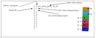
GAL files are used in the Repast when using OpenMap. GAL stands for GenePix Array List and which provides an easy way to link between location and the quantitative values that represent each agent (polygon). Basically it is a text file with specific information and used within the program to create an array list. They are easily created using VB in ArcGIS. The GAL file contains information about the number of polygons In the case below it is 0 to 6(the last polygon in the list), the file name (all_data_small) and the column name (ID_ID) where the polygon id can be found (See diagram below). Alternatively can be created using GeoDa, a freely downloadable program designed to implement techniques for exploratory spatial data analysis (ESDA) on lattice data (points and polygons).

An annotated example of a .GAL file and the associated shapefile with the polygons numbered accordingly.

Monday, March 13, 2006

Surname Profiler

The SurnameProfiler from UCL 'Spatial Literacy in Teaching' Website allows family name enthusiasts to make searches on the geography of the most frequent 25,000 surnames in Britain (between 1881 and 1998). Maps show their historic and current distributions in Great Britain (as seen the the left and below). The website also gives other information on family names. For example, the surname Crooks there were 230 occurrences in 1881 and 3535 (1226 increase) in 1998. In 1881, Crooks were over represented in the Midlands but by 1998 had moved north. In 1881, Crooks was ranked the 1936 popular surname while in 1998 it had risen to 1725. The surname Crooks ideriveded (origninated) from Celtic; Irish; Other Northern Irish

The website was designed to investigate the distribution of surnames in Great Britain, both current and historic, in order to understand patterns of regional economic development, population movement and cultural identity. This website allows users to search the databases that they have created, and to trace the geography and history of their family names.

The spatial literacy website also had a very good conference the other day called ‘Spatial Literacy in Teaching: Communicating GIScience’. 8 speakers presented a range of recent developments in spatial analysis, software and pedagogy. Including Professors Batty and Longley (from UCL), Janelle, (University of California, Santa Barbara), David Maguire (ESRI Inc., Redlands, CA). All their presentations can be downloaded from the spatial literacy website.